


Top 5 Hard, Demanding Hikes Near Vancouver, BC to Complete This Fall


Looking for the best, most difficult hiking trails to tackle this autumn?
Vancouver is a playground for adventurers. Sitting between the ocean and the mountains, the area attracts outdoor enthusiasts from around the globe. Vancouver has it all.
This list compiles the top five hikes within 200 kilometres of Vancouver that are sure to make you sweat for those scenic views. But trust me, it’ll be worth it. Fall is in the air and that summer breeze has been replaced with a slight chill. This can only mean one thing: winter is just around the corner. There’s still time to squeeze the last of those adventurous hikes into the alpine.
Note: Always arrive prepared for snowy conditions when hiking in the mountains. Leave a detailed trip plan with a trusted person, check recent trail conditions and pack survival gear in case of a sudden need to stay overnight. Be safe, have fun and live the adventure!
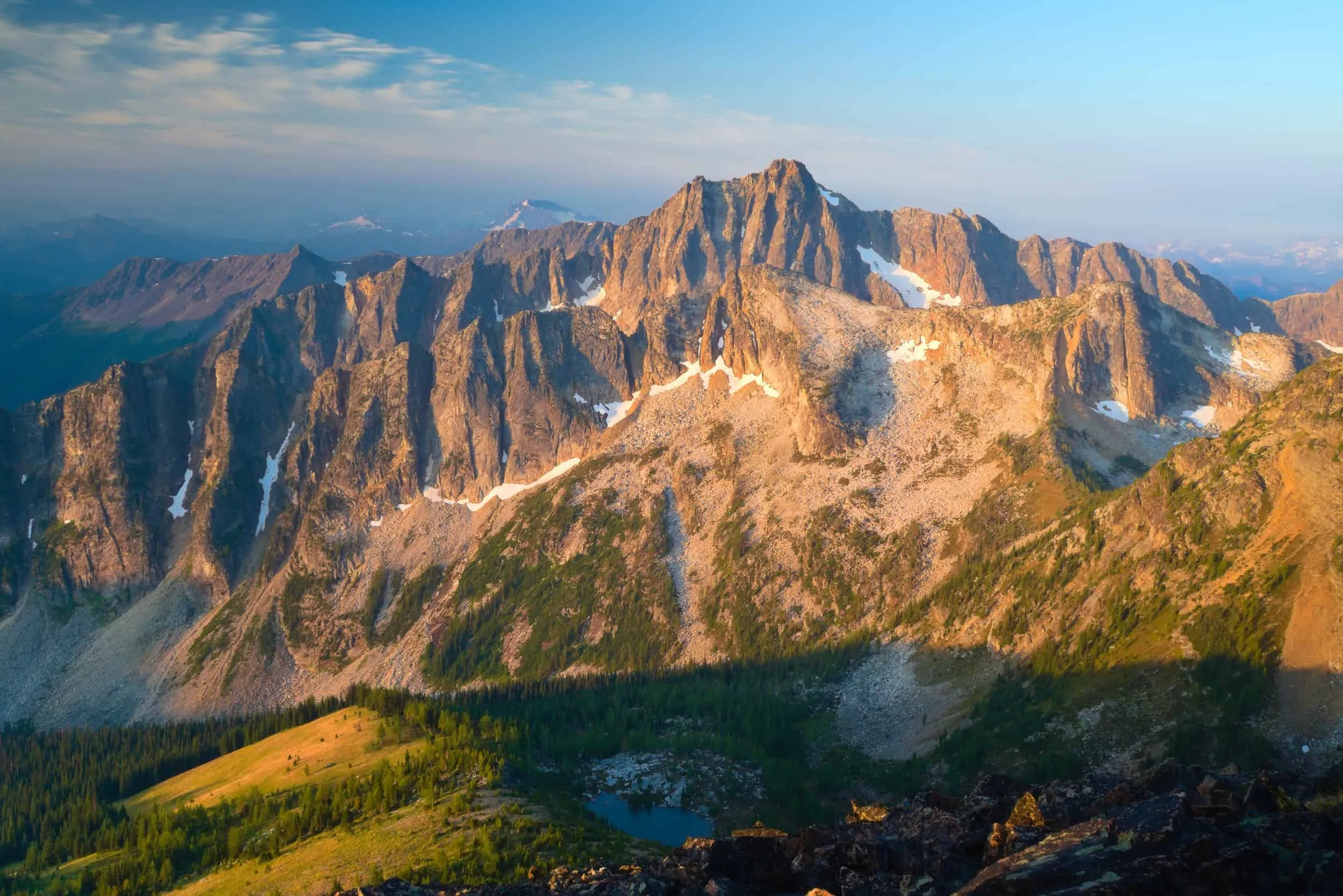
Zupjok, Llama and Alpaca

Length: 19.6 km (out-and-back)
Elevation Gain: 1,424 m
Distance from Vancouver: 198 km
Details: We start this list with a hike that provides stunning views of the unique landscape found in the surrounding areas of the Coquihalla Summit Recreation Area. This hike begins at a rest area alongside the Coquihalla Highway, at the foot of the prominent Yak Peak. Here you will walk along a relatively flat forest service road for approximately four kilometres until the trail separates from the road, leading into the forest where you will begin your ascent.
After a relatively short climb you will reach the first of the three peaks, Zupjok. Here, you’ll be rewarded with a spectacular view of the mountain tops carved into the granite rock. Continue along the ridge that rolls down and climbs back up towards the final two peaks, Llama and Alpaca.
The summit of Alpaca peak affords adjacent views of the impressive Vicuna peak, which sits a stone’s throw away and might tempt a return visit to the area.
Read more: alltrails.com
Needle Peak & Flatiron Lake

Length: 8.5 km (out-and-back)
Elevation Gain: 818 m
Distance from Vancouver: 198 km
Details: Also located in the Coquihalla Summit Recreation Area (on the opposite side of the highway) is the trailhead for the hike to Needle Peak. This hike begins with a very steep incline through the woods, navigating fallen trees and climbing over exposed tree roots through steep sections of muddy terrain. The trail then emerges at a large boulder field, after which you’ll make your final ascent to the peak.
From this point, you can either turn right towards Flatiron peak or turn left and begin the ascent to the summit of Needle Peak. If you have the energy, take the trail towards Flatiron and make a pit-stop at Flatiron Lake which sits just below its summit. Have some lunch and take in the jaw-dropping views, with Needle Peak providing the perfect backdrop. After a short break at Flatiron Lake, head back to the intersection on the trail and begin your climb towards the peak. This climb becomes a scramble in sections and at some points is aided by ropes. When you reach the summit, you will be rewarded with 360-degree views.
Read more: hikingforthescaredycat.com
Frosty Mountain
Length: 27 km (out-and-back)
Elevation Gain: 1,644 m
Distance from Vancouver: 223 km
Details: Though the Frosty Mountain trail is rather far from Vancouver, E.C. Manning Provincial Park’s rugged beauty will leave you breathless (and so will this hiking trail). Manning Provincial Park is also home to some of the oldest trees in Canada, the well-known alpine larches. If you’re lucky enough to be visiting the area in September or October, you will witness the needles of these wonderful larches begin to turn a fiery yellow colour, giving rise to the elusive wonder: the golden larches.
The trail to Frosty Mountain begins at Lightning Lake, where you will enter the woods and begin the uphill journey. The climb is fairly gradual as it winds through the mountains, following many switchbacks along the way. Shortly after passing the Frosty Creek campsite, the trail will begin to level out as you pass the alpine larches, and the summit will be within sight. The last push to the summit involves a small scramble, taking you towards a ridge line that leads to the peak of Frosty Mountain.
Sitting at 2,408 metres, Frosty Mountain is the highest peak on this list. This peak provides staggering views of the surrounding North Cascades Mountain Range, with Castle Peak to the south looking particularly remarkable, as well as providing splendid views of the landscapes throughout Manning Provincial Park.
Read more: happiestoutdoors.ca
Mount Brunswick

Length: 15.1 km (out-and-back)
Elevation Gain: 1,555 m
Distance from Vancouver: 33 km
Details: The hike to Mt. Brunswick is among one of the shortest hikes on this list—but don’t let that fool you. This hike takes you to the peak of the highest mountain in the North Shore, sitting at 1,788 metres.
After a gruelling hike, composed of switchbacks and a continuous uphill climb, with a final scrambling section that will have you on both your hands and knees, you will reach the tall peak. The views from here are truly spectacular and allow you to appreciate the beauty of Vancouver from a very unique perspective.
The far-reaching views stretch South, beyond the city to Washington’s notorious Mt. Baker, West to the Vancouver Island Ranges and as far north as the prominent Black Tusk. The relentless hike to the peak is outweighed by the feeling of standing on top of the world.
Read more: outdoorvancouver.ca
Panorama Ridge (via Helm Creek Campground)

Length: 29.1 km (out-and-back)
Elevation Gain: 1,573 m
Distance from Vancouver: 95 km
Details: Home to the infamous Black Tusk and the tranquil, turquoise waters of Garibaldi Lake, Garibaldi Provincial Park is a stunning area. This hike begins at the Cheakamus Lake parking lot and takes you through enchanting woodland trails, leading towards Cheakamus Lake. The trail to Panorama Ridge veers right at the junction, before crossing the Cheakamus River and starting your climb. This section of the hike becomes steep for a short stretch but becomes more gradual before reaching the meadows, where you will find the Helm Creek Campground. From here the trail winds through the woods, crossing several creeks and opening to provide spectacularly striking views of Black Tusk.
Continuing along the trail, you will begin your ascent to Panorama Ridge. Look down for views of Black Tusk Lake. After a relatively short climb over steep, uneven terrain, combined with a short scramble, you will reach the summit of the aptly named Panorama Ridge.
From here you will be rewarded with the rough and rugged views of mountainous landscape in the surrounding area of Garibaldi Provincial Park, coupled with beautifully picturesque glaciers in the distance. The views from the ridge are forever memorable and although this hike comes in at a staggering 29 kilometres roundtrip, this does not stop most locals and keen adventurers from all over from venturing out each year.
Read more: vancouvertrails.com

What do you think? Are these the best difficult hiking trails near Vancouver?
Comment on Facebook


