Hiking Trail Review: Thru-Hiking Mount Assiniboine Provincial Park
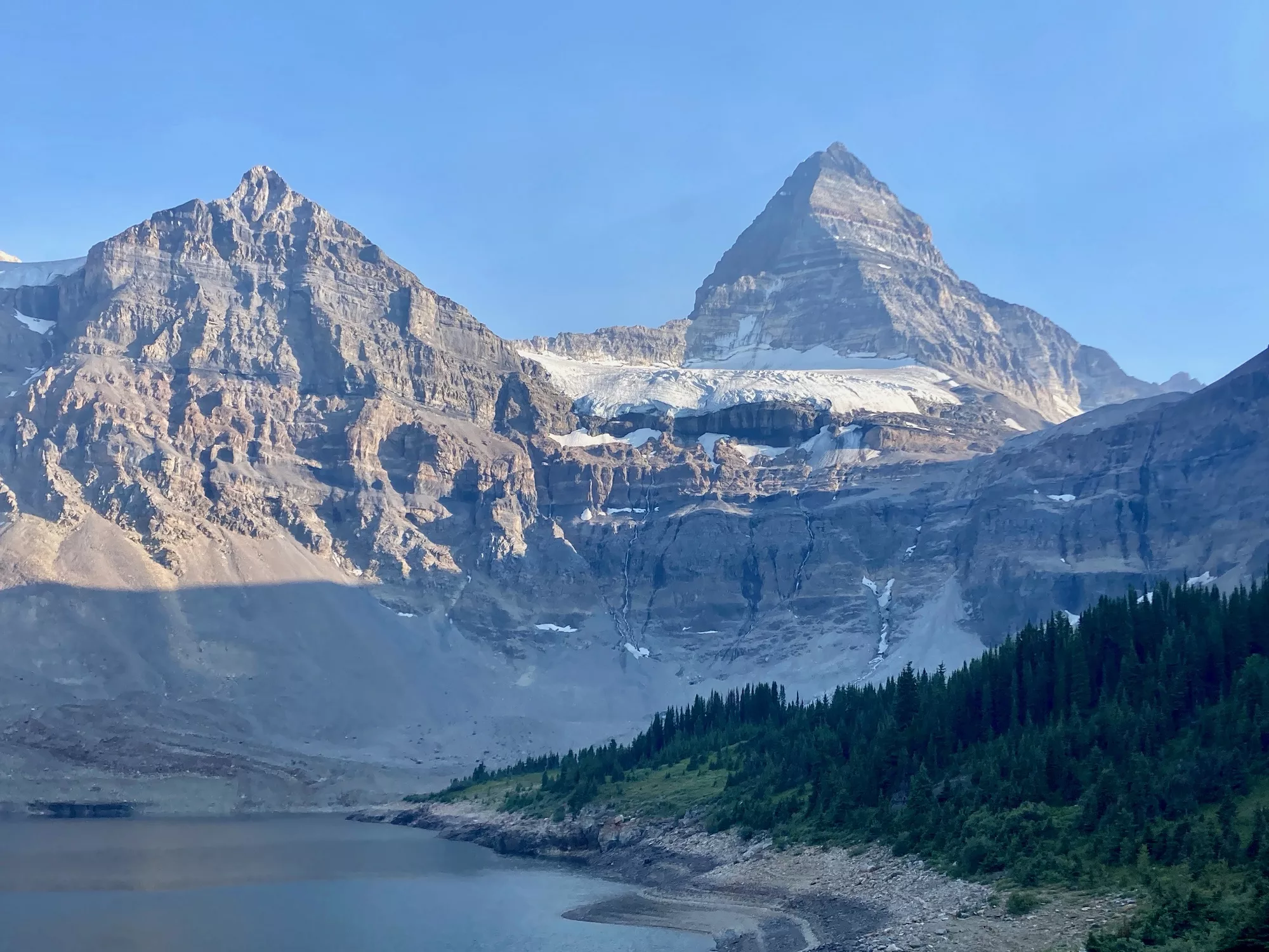
Location: Mount Assiniboine Provincial Park
Park Here: Park at either the Banff Sunshine Village Ski Resort or the Mount Shark Trailhead in Kananaskis Country (permit required)
Public Transport: A free shuttle is available from the Banff town centre to Sunshine Village
Hike Distance: At least 55 km one way
Hike Duration: 1-6 days depending on itinerary
Elevation Gain/Loss: 1,900 m
Difficulty: Challenging
What makes it challenging? The trail is well-marked, easy to follow and elevation is often gained gradually. What makes this hike challenging is the sheer length, some steep sections over mountain passes and the need to have enough backcountry skills and awareness to safely complete a thru-hike.
Park website: Click here

Mount Assiniboine is known as the Matterhorn of the Rockies—and for good reason. Towering at an elevation of 3,618 metres over the azure Lake Magog, the mountain is postcard-perfect and well worth the multi-day trek through Ktunaxa traditional territory to get there.
It was the ideal location for my first solo thru-hike, where I spent four soul-nourishing days walking 55 kilometres along one of British Columbia’s most coveted trails. Mount Assiniboine is situated along the Great Divide Trail that traces the BC-Alberta border, meaning you’re bound to run into some long haulers embarking on two-month treks!
Finding the Trailhead

There are two main access points for this trail: the Banff Sunshine Village ski resort or the Mount Shark Trailhead in Kananaskis Country. Most people hiking the full trek will start at Banff Sunshine Village and end at the Mount Shark Trailhead. This route provides more gradual elevation gain, while also offering more rewarding views as you’ll have Mount Assiniboine unfolding in view for a longer amount of time.
To complete a through-hike, you’ll need to coordinate your transportation ahead of time. It’s easiest to bring two cars, parking one at Mount Shark and driving the other to the starting trailhead at Banff Sunshine Village. Alternatively, you can try to arrange a ride with fellow hikers on Facebook.
It’s also common to hitchhike, which is what I did. I drove my car down the bumpy but scenic Smith Dorrien Trail (Highway 742) and parked at the Mount Shark Trailhead. I then hitchhiked from the Mount Shark Trailhead back to Canmore, where I took public transit back to Banff. Without a second car, I camped in the Banff National Park front-country at Tunnel Mountain Village 1 (National Parks Discovery Pass required).
From there, I took a free public bus straight from the campground to the Banff town centre, where I proceeded to hop on the free Banff Sunshine Village shuttle to the Sunshine Village ski resort, where I would start the hike.
Many people also opt to hike out-and-back routes from either Sunshine Village or Mount Shark, so that they can start and finish the hike in the same location, avoiding the hassle of coordinating transportation.
The Hike Itself
Day 1: Sunshine Village to Og Lake (22 km)
For most, the hike starts with a gondola ride at Sunshine Village. This way you avoid slogging ascending 500 metres up a boring six-kilometre gravel road through the ski hill, adding to an already-long first day. If you’re thru-hiking, ask for a one-way ticket.
Once at the top, get your camera ready: the views are immediately amazing as soon as your boots touch the ground.

Trekkers can either keep left for a more immediate route on the Citadel Pass Trail or take the short Rock Isle Lake detour, which I would recommend. Both trails are very well-marked.
Following the Citadel Pass Trail, you’ll head uphill to Quartz Ride before traveling steeply down again to Howard Douglas Lake (six kilometres). This is the last reliable water source on the trail, as many streams that appear on the map can be dried out.

Past Howard Douglas Lake, the trail traverses an expansive meadow before hitting that day’s high point at Citadel Pass—the perfect lunch stop for those heading to the first-come-first-served Porcupine campground (at 13 kilometres) or all the way to Og Lake (22 kilometres), as I was. While travelling all the way to Og Lake makes for a longer day, it avoids unnecessary elevation loss that’s unavoidable if you go to Porcupine.

After a series of steep switchbacks, the rest of the trail is a time-consuming jaunt of continuous elevation gain and loss as you navigate small rolling hills all the way to Og Lake.

On arrival at Og Lake, your first jaw-dropping look at Mount Assiniboine will unfold into view, stoking inspiration for the next day’s journey. Thanks to communal cooking areas and shared bear caches, you’re likely to make some trail friends at the campground.
Day 2: Og Lake to Magog Lake (6.5 km)
As a reward for a long first day, the hike from Og Lake to Magog Lake is a short walk with minimal elevation gain through a blooming meadow (home to my only grizzly sighting on the trail!)
Getting an early start will give you lots of time to set up at the Magog Lake campground, often referred to as the Mount Assiniboine core area. Alternatively, you can book a stay at the Assiniboine Lodge or Naiset Huts nearby. Some people opt to take a helicopter into the core area instead of hiking.

With camp set up for the night, you can spend the afternoon dipping into the four turquoise glacial lakes in the area: Magog, Sunburst, Cerulean and Elizabeth. After careful consideration, I decided Cerulean was the best spot for a polar swim!

Day 3: The Niblet, Nublet and Nub
I stayed at the Magog Lake campground for two nights to give myself time to explore the core area. One of the core area’s most popular day hikes is The Niblet, Nublet and Nub Peak. With only 550 metres elevation gain, this is an accessible, three-for-one peak with multiple plateaus with epic views of the surrounding area.

Experienced hikers may also like to scramble to The Towers, Sunburst Peak or Mount Cautley, which are all within the core area.
I capped off another beautiful day with happy hour at the Assiniboine Lodge, which was open to campers from 4 to 5 p.m. on non-heli days (a sign at the Magog Lake campground is where you’ll find up-to-date information).
Day 4: Magog Lake to Mount Shark Trailhead via Wonder Pass (27 km)
On the final day, hikers can take their pick between two routes from Magog Lake to the Mount Shark Trailhead: Wonder Pass or Assiniboine Pass.
The Wonder Pass route is longer, but generally agreed to have the most breathtaking views over Marvel Lake. You may opt for Assiniboine Pass if you’re looking for a more direct route, but it is closed seasonally starting August 1st due to grizzly activity.

I took Wonder Pass and hiked out in one day, which is a long but doable trip that takes an average of eight hours to complete. Many hikers, however, choose to spend another night at the McBride’s, Marvel Lake or Big Springs campgrounds to break up the journey.

Marvel Lake is a great spot for lunch—and you might just run into a moose on the trail, like I did!
After lunch, the trail becomes a fast and double-wide dirt track with minimal elevation gain and loss, so you can cover ground quickly through the forest and back to your car at the Mount Shark Trailhead.
Before You Go:
- Make backcountry camping reservations for Og Lake and Magog Lake. BC Parks opens their reservations on a rolling system four months in advance of your trip. Be online as soon as reservations open, as these book up fast!
- Be bear aware, as grizzly sightings are common. Bring bear spray and use the communal cooking areas and bear caches available at every campsite.
- Ensure you pack enough water. Each season will be different, but it’s increasingly common for streams shown on the map to be dried up.
- Download offline versions of the trail map to help you navigate, as you’ll be out of cell service for the entire trip. Fatmap, Gaia or AllTrails are recommended.
- Dogs are allowed on leash.
More Hiking Trail Reviews:
Hiking Trail Review: Fintry Falls, Kelowna, BC
Hiking Trail Review: Badlands Trail, Dinosaur Provincial Park, AB
Hiking Trail Review: Rouge Valley Mast Trail, Toronto, ON


