


4 Incredible Canadian Backcountry Adventures

Sue Falls Loop
Quetico Provincial Park, ON
At 460,000 hectares with 2,200 backcountry campsites, whether by paddle or by foot you’ll be able to find some solitude to commune with the loons in Quetico Provincial Park. While the park features nine marked trails, some of which connect to interior backpacking trips, it is best explored via canoe. If you like your portages brief, tackle the 65-km Sue Falls Loop. Usually done over four days, this route starts on Beaverhouse Lake then travels past tumbling Sue Falls and Aboriginal pictographs along the north shore of Quetico Lake before looping back to Beaverhouse. There is only one lengthy portage, other than that the walks are short and the paddles are long.
Dates: June to September
For More Info: ontarioparks.com/park/quetico
Les Lacs & Les Cretes
Forillon National Park, QC
Tucked away at the edge of Quebec’s Gaspe Peninsula, Forillon National Park offers not only exemplary Maritime scenery, it’s also a gateway to the International Appalachian Trail. Experienced hikers should head to Les Lacs (17 km one-way) or Les Cretes (16 or 18 km, one-way) Trails. Les Lacs follows the Riviere Morris Valley, has a wilderness campsite about six kilometres along and passes Lac au Renard and Penouille and other scenic stillwaters before connecting to the 3,058-km-long Appalachian Trail. As a more mountainous route, Les Cretes offers vistas of the Gulf of St. Lawrence and Anse-au-Griffon Valley, has campsites at five and 10 km along and connects to other trails (such as Les Graves) leading to the easternmost tip of the park, which stabs like a pointed finger into Gaspé Bay.
Dates: June to September
For More Info: pc.gc.ca/forillon
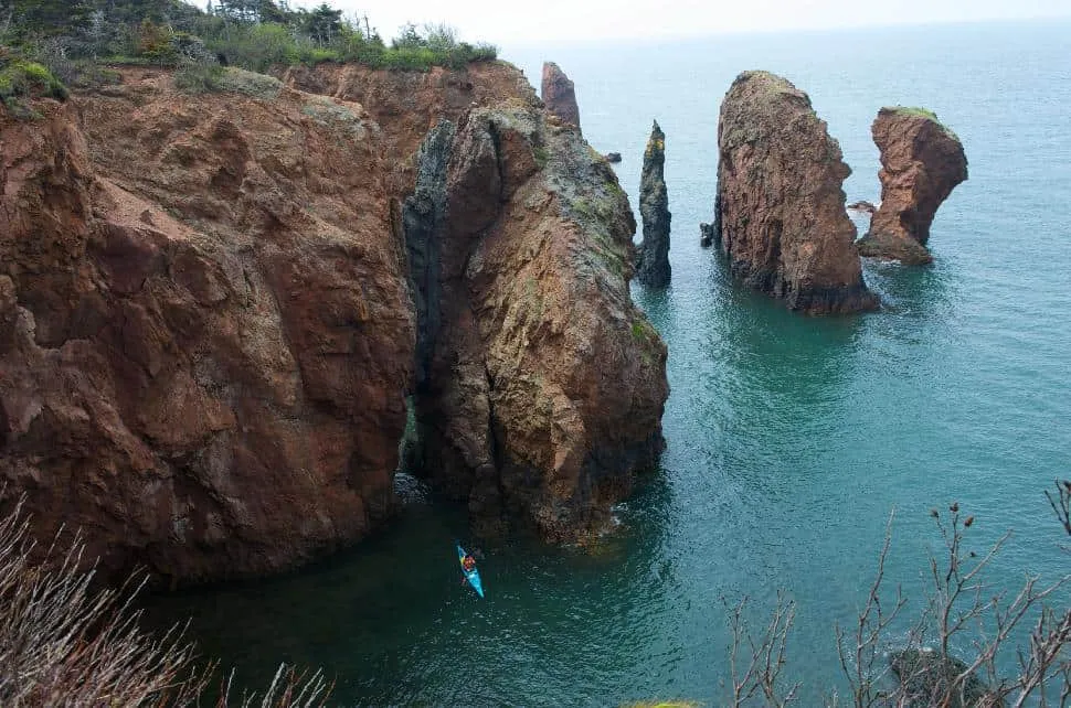
Coastal Loop
Cape Chignecto Provincial Park, NS (pictured)
Accented by the famous Bay of Fundy tides ebbing-and-flowing below, views from atop Cape Chignecto Provincial Park’s 180-metre-tall sea cliffs reduce one to mumbling superlatives. And the best way to fully experience this scenic Atlantic preserve is via the 52-km-long Coastal Loop. Starting off as an easy front-country trek, be prepared to get serious after 12 km — watch your footing between Mill Brook and Refugee Cove, where the trail becomes a series of switchbacks, and onward to Big Bald Rock, where it runs along the steepest sea cliffs in the province. There are seven backcountry campsites along the Loop; most trekkers take three nights to complete the route. Kayakers also flock to the park to paddle through the 35-metre-tall sea stacks along the coast.
Dates: May to October
For More Info: novascotiaparks.ca
Be One of the Few
Aulavik National Park, NT
Looking to disconnect? Rest assured, there are no Wi-Fi zones in Aulavik National Park. In fact, other than a dirt airstrip, there is no development at all. True adventurers make the trip to Banks Island to experience 12,000-sq-km of tundra, badlands and polar desert — retracing travel routes used by Pre-Dorset, Eastern Arctic Dorset, Thule and Inuit nomads over the past 3,500 years. Aulavik is also home to the country’s most northerly navigable river; the remote Thomsen River is a bucket list item for serous canoeists. And you might not be totally alone — since the park holds the world’s highest concentration of muskox, a herd is probably lurking over the next ridge. The word Aulavik means, “place where people travel,” which begs the question: how do you get there? Your charter flight beings in Inuvik, 750 km southwest; savvy travellers share costs with other groups flying into the park. It’s not easy, but the best things never are.
Dates: Late-June to mid-August
For More Info: pc.gc.ca/aulavik
This article originally appeared in our Summer 2014 issue.


