


Hiking the Incredible Sunshine Coast Trail

Highlighting expansive coastal and mountain vistas, meandering through old-growth rainforest and dotted with trailside huts, the 180-km Sunshine Coast Trail is a world-class hiking route just a half-day trip from downtown Vancouver.
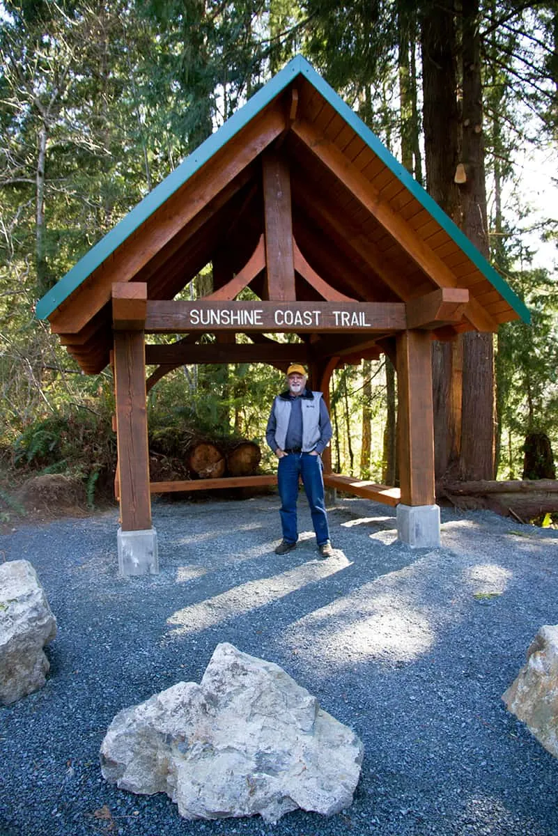
“The Sunshine Coast Trail is Canada’s longest hut-to-hut hiking trail—and the only free one. This is our claim to fame,” explains Eagle Walz, trail co-founder and president of the Powell River Parks & Wilderness Society who maintain the trail.
Rambling from Sarah Point to Saltery Bay on British Columbia’s Northern Sunshine Coast, the SCT is accessed from 11 different points and offers pleasant day or multi-day routes. Some intrepid hikers have even tackled the entire trail for a two-week epic trek that wanders along beaches, into the alpine, past cerulean lakes and through the town of Powell River for a mid-hike pub night. However you decide to explore, you’re welcome to utilize the 12 huts and 20 tent-sites (most with outhouses and fire pits)—all of which are free-of-charge and do not require reservations.
Fully established in 2000 after eight years of work by the PRPAWS—headed up by Eagle Walz and Scott Glaspey—this unique trail system remains off-radar for many outdoors people. Explore spoke with Eagle Walz about this incredible hiking experience—to learn the trail’s history, tips and tactics and to shed some light on one of Canada’s great hiking routes.
SCT Origins
                            <div id="articleImage60313" class="articleImage">
                                <img src="https://explore-mag.com/wp-content/uploads/2024/02/60313_max-jpg.webp" style="display: block; margin-left: auto; margin-right: auto;">
                                <div class="imageCredit">Credit: Jeremy Williams, Sunshine Coast Tourism</div>

                            </div>
Walz’s initial idea, which would develop into the Sunshine Coast Trail, dates back to 1992. As Walz explains, he was driving from Lund to Powell River, and, for the first time, he noticed a clear-cut right next to the highway.
“I found out that there was more and more logging happening in the front-country, because the back-country was being exhausted,” he explains. As he investigated further, he also discovered there weren’t many hiking trails in the area—only about five marked trails existed at the time. These trails were only known to locals, who usually wouldn’t share details—so they were just utilized by a close circle of acquaintances.
“If you didn’t know them, tough luck,” says Walz. “But I did find out that the logging was going after the few remaining patches of front-country old-growth in Powell River, and these were disappearing rapidly.” Walz imagined that if people only knew where these beautiful places were, and were able to access them, they might want to help save them.
“At about that time, I ran into who would turn out to be my sidekick for all these years—Scott Glaspey—who was also interested in building trails,” continues Walz. “We said—why don’t we see if we can build a long-distance hiking trail that connects some of these last remaining patches of old growth in the front-country of Powell River?”
Walz and Glaspey connected with other like-minded people and formed the Powell River Parks and Wilderness Society (PRPAWS), which incorporated as a not-for-profit in 1993.
“One of the purposes we have is to save patches of old growth in a variety of settings… and to connect them with a hiking corridor,” says Walz. “That was the job, we set to it, and we haven’t stopped since then.”
What To Expect on the SCT
                            <div id="articleImage60311" class="articleImage">
                                <img src="https://explore-mag.com/wp-content/uploads/2024/02/60311_max-jpg.webp" style="display: block; margin-left: auto; margin-right: auto;">
                                <div class="imageCredit">Credit: Emma Levez Larocque, Sunshine Coast Tourism</div>

                            </div>
“We have built 11 huts and a kiosk, which are each spaced roughly 15 to 20 km apart—a good day’s trip—so you can hike from hut to hut. We do not charge for the use of the trail or the use of the cabins, which are used on a first-come, first served basis—but also shared use,” explains Walz, adding that construction of a new hut—possibly the final one—is set to be completed this October. “We are adding additional campsites around the huts and at other locations as well.”
One might expect such a scenic and easily accessed trail to be heavily trod. Not so, says Walz. “We ask that hikers travel from north to south, that way they will encounter fewer people, as they are in lockstep… you get more of a solitary experience that way.”
That, combined with 180 km of wilderness, along with the less-travelled nature of the Sunshine Coast in general, ensures hiking serenity. Overnight explorers may find company at the huts; those looking for total privacy should pack a tent.
Trail-work is ongoing—new markers, benches and picnic sites have recently been installed, and a $160,000 grant from the Island Coastal Economic Trust (which the PRPAWS is matching in-kind with labour) is being allocated to trail maintenance and improvements throughout.
“This is an all-season trail—24/7 and all year long—as some sections remain snow-free,” Walz explains. “We aim to be world-class, and we’re on the way to being there. Some people think we’re there already. We don’t. There are sections that are world-class—and we’re making more and more of them that way until we are happy.”
Insider tip: Before setting out on your first leg, stop by the Powell River Visitor’s Centre (4760 Joyce Avenue – MAP) to sign-in and purchase a Sunshine Coast Trail Passport ($5). Then, take a selfie at every hut you visit and show this snapshot to local sponsor businesses to collect an official hut stamp—some retailers offer special deals for stamp-collectors. Visit all 12 huts and you’ll join an elite crew of SCT Finishers and will receive a complimentary “completion certificate” at the Visitor Centre.
Eagle Walz’s Top SCT Hiking Routes
Here are three great routes from the trail’s premier expert:
Multi-Day: Sarah Point to Powell Lake
“One of my favourite sections is from Sarah Point to Powell Lake. That’s about a three- or four-day trip. A water taxi out of Lund—which takes about half-an-hour—drops you off at Sarah Point. It’s nice little mini-cruise right into Desolation Sound,” says Walz. On this leg, he explains, hikers start in Malaspina Provincial Park (which the PRPAWS helped to create) and can expect stunning views over Desolation Sound, plenty of towering evergreens and several pristine lakes.
Begin your trip by booking the water taxi to Sarah Bay, in Desolation Sound, which will take you to the land’s end trailhead at Sarah Point. Day one leads along the coast and upslope to Manzanita Hut, picturesquely set on its namesake bluff. Camp overnight in this partially enclosed shelter with a view of Lund, Savary Island, the Strait of Georgia and Vancouver Island. Day two leads further into the forest as it descends towards Lund and onward to beautiful Powell Lake and Rieveley’s Pond Hut (see below), before passing Sliammon Lake and arriving at Powell Lake and the town of Powell River.
Two-Day: Mount Troubridge
“Troubridge has oceanfront for a good stretch of the way to Fairview Bay—there is a cabin there—and from Fairview Bay, you start hiking up from zero metres to 1,305 metres,” explains Walz. Hikers ascend to Rainy Day Lake, at about 400 metres (a hut is located here) before reaching the Mount Troubridge summit—the highest point on the SCT. A beautiful fully-enclosed log cabin awaits on the other side of the peak, alongside Jocelyn Pond. Day two involves a descent through old-growth on the next leg of this challenging trek.
Day Trip: Rieveley’s Pond Hut
“A great one-day trip is to Rieveley’s Pond, using the Appleton Canyon, which has Appleton Creek running through it,” says Walz. This moderate three-hour hike leads past waterfalls and into an ecosystem rich with wildlife en route to Rieveley’s Pond Hut, an open shelter nicknamed “Frog Chorus Hut.” (You’ll find out why.)
Click here for Geo-Referenced Trail Maps
Insider Trail Tips
                            <div id="articleImage60310" class="articleImage">
                                <img src="https://explore-mag.com/wp-content/uploads/2024/02/60310_max-jpg.webp" style="display: block; margin-left: auto; margin-right: auto;">
                                <div class="imageCredit">Credit: Emma Levez Larocque, Sunshine Coast Tourism</div>

                            </div>
• Always be aware of the location of water sources, and ensure you have an ample supply of fresh water (purification required).
• Carry whatever you need and adhere to Leave No Trace principles.
• Some cabins are open on two or three sides, with sleeping lofts; others are fully enclosed with wood pellet stoves (you can buy pellets at the Visitor Info Centre). Carry a small backpacking tent in case a cabin is at maximum occupancy (or for privacy).
• Pack a camp stove for cooking—some cabins have stoves, but “don’t count on it,” says Walz.
• Find a full list of tips at sunshinecoast-trail.com/whattobring.html
How to Get There
                            <div id="articleImage60308" class="articleImage">
                                <img src="https://explore-mag.com/wp-content/uploads/2024/02/60308_max-jpg.webp" style="display: block; margin-left: auto; margin-right: auto;">
                                <div class="imageCredit">Credit: Brian K Smith, Sunshine Coast Tourism</div>

                            </div>
Getting to the Sunshine Coast is easy. “It takes half-an-hour to get to our airport from Vancouver. You can be on the trail in another 15 minutes and off you go!” Walz explains.
Access Powell River via BC Ferries sailing from Vancouver (Horseshoe Bay and Sechelt) or Vancouver Island (Comox) or via flight from Vancouver International Airport South Terminal.
For more info visit the official website of the Sunshine Coast Trail:
sunshinecoasttrail.com
Ready to live the experience?
Let Sunshine Coast Tourism help plan your trip


