


Hiking the Syncline Loop Trail in Canyonlands National Park, Utah


The Syncline Loop Trail is tucked away in one of the most interesting of Canyonlands National Park‘s four districts: Island in the Sky, where high mesas mark the junction of the Green and Colorado Rivers.
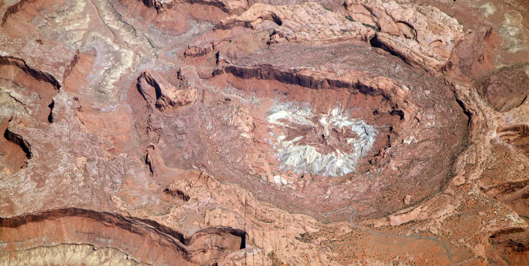
One of the highlights of this area is the massive Upheaval Dome, which the Syncline Loop Trail traces on its difficult 9-mile journey. It was once thought that Upheaval Dome was a collapsed salt dome, but new geological evidence has found that it is actually an impact crater left from some particularly hefty space rock that fell to Earth. While some crater trails present pretty smooth trekking, the Syncline Trail tests the mettle of those who challenge it with steep ledges, massive boulders and steep slickrock. The trail alone will pack in a full day of hiking in the hot Utah sun, but for those who explore the numerous spur trails, the Syncline Loop Trail could be a multi-day affair.
Quick Stats:
| Trail Length: | 9.6 miles | City/State: | Moab, Utah |
Bikes Allowed: | No |
| Elevation: | 2,340 feet gain |
County: | Grand | Dogs Allowed: | No |
Getting There:
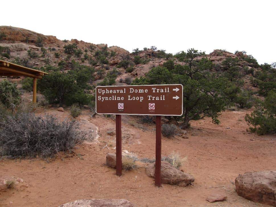
From Moab, hikers should head north on US-191 for 11 miles and turn left onto UT-313W. Continue travelling for another 14 miles and keep straight when the road splits into Grand View Point Road as it enters Canyonlands National Park. In 13 miles, turn left onto Upheaval Dome Road (it’s just past the trailhead for Mesa Arch) which will dead-end into the Syncline Loop trailhead.
The Hike:
 Flickr/Ken Lund (CC by SA 2.0)
At the trailhead
Just after getting out of the car, hikers will soon learn that “warnings” are the name of the game on the Syncline Loop Trail. Certainly, they are there for good reason as the trail can be confusing to follow and many hikers have gotten lost here, but the abundance of warning signs make them easy to ignore. Visitors should be sure to consider the “this trail is primitive and difficult to follow” sign as well as the “bring enough water” warning. On warm days, even in early spring or late fall, bring more water than you think you will need. If none of that puts you off, then you are truly ready for some of the most remote hiking in the American Southwest.
Setting out
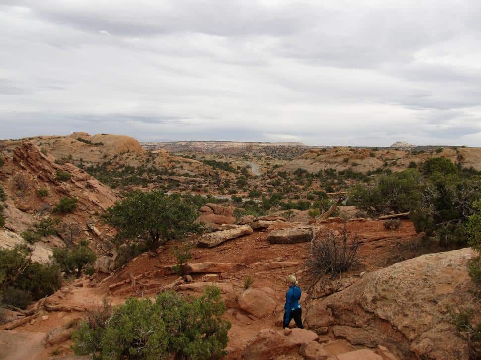
The trail begins with a short climb up to the rim of the dome, but after a few minutes of kicking up desert dust, hikers are rewarded with their first view of canyon country.
What makes Canyonlands so special is that on clear days, visitors can easily see 50 miles into the distance. Hikers will see mesas and buttes as well as dark canyons, running like veins through the desert’s skin.
Following the trail, hikers head down into Upheaval Canyon, a trail that, with the proper backcountry permit, hikers can follow all the way to the Green River. However, those following the Syncline Loop require no permit.
Into the canyon
The trail in the canyon starts its deep descent, losing more than a thousand feet of elevation in just under a mile. While the rock-studded canyon walk will be a test of the knees, there are patches of primrose and desert clover throughout to add some contrast to the bright canyon walls. After about a mile of switchbacks, hikers travel up a small plateau known as “the gap”. Make use of this flat and stunningly scenic area to rest up a bit, as the other side of the gap is more the same.
From the gap, the trail drops through a rocky talus field, but eventually levels out into the wash. While the trail still travels at a downward angle, the wash is less rocky and much more manageable. Unfortunately, hikers will now have to deal with a desert hiker’s enemy: soft sand.
Also, hikers need to be cautious of the weather in this area, as with any wash, it is prone to flash floods. In early spring, hikers may spot some water trickling through the area that fuels the cottonwoods and patches of wispy desert grass. However, be aware that it is not safe to drink without first filtering it.
What is most stunning about the wash area is watching how the canyon walls change. They begin as red sandstone, much like the previous leg of the hike, but slowly transform to a grey pallor as shale and rim sandstone were pushed upwards after the meteor impact.
 Flickr/Ken Lund (CC by SA 2.0)
Navigating the spurs
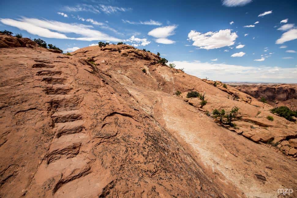
At the three mile mark, the wash ends in a junction of canyons and trails. To the left is Steer Mesa and to the right is Bighorn Mesa. They both disappear to the west into Upheaval Canyon. This seven mile round-trip will add another day onto the hike and requires a permit, but the Green River Overlook that it leads to does provide a striking view out over the park. For the Syncline Loop, keep right and just after leaving the junction take another right at the second junction, leaving Upheaval Canyon behind. Hikers will know it on sight due the set of carved stone steps that lead up.
At the top of the stairs, be careful not to accidently turn on the false trails that meanders off to the left above Upheaval Canyon. Hikers will want to continue going up and over another wide sandy wash that slithers between two tall rock columns.
 Flickr.com/mzagerp (CC by ND 2.0)
As hikers reach the backcountry camping area, the canyons opens up into a valley of rolling sandstone, desert grass and flowering cacti. The stream bed near the camping area may or may not have water in it, but regardless, this area makes a beautiful place for a break.
Continuing on with the trail, hikers will come to a spur trail about three-fourths of a mile in. This is a side trip that is recommended; it is about three miles round trip and leads into the Upheaval Dome on a relatively flat trek. Inside, hikers can see the white powder on the rocks and in the wash that caused geologists to originally think the area was a collapsed salt dome. However, for hikers who are getting tired and need to start making miles count, it might be wise to continue on the Syncline.
Bring on the bouldering
The main trail starts back up easy enough on hard packed dirt as it winds its way through sage and cottonwood. However, as the canyon begins to narrow and the rocks begin to grow ever larger, hikers will know the bouldering section of the trail is coming. From afar, it looks like the canyon dead ends, but there are little pathways through. This section involves squeezing under boulders barely big enough for you and your pack, carefully choosing footholds and shimmying up against rocks. With a 35% grade across one quarter of a mile, this section is tough on the body.
Upon reaching the canyon notch, the trail continues to torture with a steep descent. However, at the bottom, the worst of it is over. There is more climbing ahead, but none quite so challenging. After the tough climb, the trail mellows out as it travels through a desert meadow of grass and creosote, but don’t get too complacent. As the glorious green oasis fades, The Breach lays ahead. The Breach is a narrow canyon that is actually a break in the walls of the Upheaval Dome. Not only is the area a tight squeeze, but it is uphill and laden with boulders. After climbing over the massive, relentless boulders, the trail turns to slickrock, but the steepness of the climb lessens.
When you get that first peak of the rim of the Upheaval Dome, The Breach has ended. The climbing is officially over. Now hikers tread through two miles of dusty soil that blows away in the breeze into walls of white sandstone. During this stretch, there are sections of the rim where you can actually drop down and head into Taylor Canyon, but for those unfamiliar with the area, it is best to keep true.
This is the last leg of the hike, so do remember to take some time to enjoy the view out over the rim, especially once that parking lot comes into view and gives a much needed boost in energy.
Have you hiked Syncline Loop Trail in Canyonlands National Park?
Let us know: drop a comment below.


