


4 Rugged Northeastern Ontario Trails to Hike This Spring

The snow is melting and that means one thing: it’s time to shed the snowshoes. Warmer weather in Northeastern Ontario has outdoor adventurers changing snow boots for hiking boots…and we just can’t resist the allure of a place that boasts big adventure in the heart of Canadian wilderness. For the arrival of spring we’ve listed four hikes in Northeastern Ontario to usher in hiking season.
Redbridge Mountain View Trail
North Bay
Trailhead: Accessed at the end of Mountain View Road
Length: 4 km
Difficulty: Hard
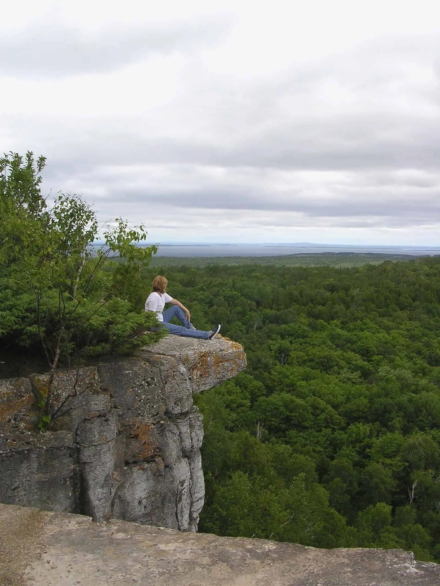
Measuring 4 kilometres round-trip, Redbridge Mountain View Trail is short, yet difficult. Fit adventurers need not worry though, the trail doesn’t present any major technical obstacles. How did this hike earn our recommendation? For its spectacular, unobstructed views of the area of course.
Redbridge Mountain View Trail climbs upwards through steep, beautiful forest and gassed legs are rewarded with a vantage point that stretches to the horizon. With few amenities in the area this is the perfect day trip for getting right into nature.
Trip planning note: From North Bay head northeast along Trout Lake Road. Turn right onto Mountain View Road. Access the trailhead by driving to the end of the road.
Plan a North Bay weekend getaway around this hike
Top-voted attraction: Cruise Lake Nipissing on the Chief Commanda II
Adventure-worthy accommodation: Spend the night in a Mongolian Yurt
Nearby craft beer breweries: New Ontario Brewing Co. & Cecil’s Brewhouse & Kitchen
Cup & Saucer Trail
Manitoulin Island
Trailhead: Located at the Junction of Highway 540 and Bidwell Road
Length: 12-14 km (cumulative)
Difficulty: Moderate
Parking: Lot parking
Don’t be surprised if the views from Manitoulin Island’s Cup & Saucer Trail seem somehow familiar; chances are you’ve seen the picture-perfect scenery grace the pages of glossy brochures. Cup & Saucer Trail traces the Manitoulin Extension of the Niagara Escarpment, treating hikers to views of the island’s iconic cliffs. The rockface measures as high as 70-metres and drops dramatically into the treeline. In summer, leafy forest canopies envelope the 2-km long escarpment.
Hikers have two options to choose from on a marked map located at the trailhead: white trail (5.5-km) or blue trail (6.5-km), with a diversion along Adventure Trail (0.5-km). The latter includes some scrambling and a few zig-zagging wooden ladders. Depending on how many side trails hikers pursue, Cup & Saucer can take 20 minutes or 4+ hours. Visitors who want a unique perspective can tour the trail with a knowledgeable First Nations guide.
Plan a Manitoulin Island weekend getaway around this hike
Top-voted attraction: Go horseback riding, on a Canoe Heritage Tour or take a guided Medicine Walk at Great Spirit Circle Trail
Adventurer-worthy accommodation: Sleep in a rustic cabin or tee pee
Nearby craft beer breweries: Split Rail Brewing Co. (on the island) & Manitoulin Brewing (travel a little further afield)
Kidney Lake Trail
Cochrane
Trailhead: Located just off Highway 668
Length: 9 km
Difficulty: Intermediate
Parking: Parking by the trailhead
It may be difficult for hikers to imagine, but at one time Greenwater Provincial Park had been cleared by farming and logging operations. Today, there are virtually no signs of a working history, just a spatter of spring-fed kettle lakes. These bodies of water which evoke potholes are evidence of a glacial past. Kidney Lake is the longest of the 26 kettle lakes contained within the park. It is nestled within scenic boreal forest and its waters are stocked with trout and perch.
Kidney Lake Trail begins near the lake’s shore where visitors can park, use a restroom and refill water bottles. Once on the path hikers weave in and out of the forest and are offered gorgeous views of pristine glacial waters. Camping is permitted in the park.
Plan a Cochrane weekend getaway around this hike
Top-voted attraction: Swim next to polar bears at the Polar Bear Habitat
Adventurer-worthy accommodation: Sleep off the grid at Kesagami Wilderness Lodge
La Cloche Silhouette Trail
Close to Sudbury

Trailhead: Located at George Lake Campground
Length: 100 km
Difficulty: Hard
Parking: Available at George Lake Campground
The difficulty of the La Cloche Silhouette Trail mostly comes from its 100-km length. Located in Killarney Provincial Park there are bits of steep and rocky stretches to keep your interest. Can’t find 10 days to hike it in its entirety? No problem; there are a number of accessible trailheads that allow casual hikers to tackle it in sections.
Multi-day backpackers will find designated campsites at the trailhead and wilderness camping along the way. Trail highlights include rolling forested hills, rocky-shored lakes, and the area’s most famous landmark: The Crack. This famous ridge features striking vistas over the rugged landscape. With all the scrambling and bouldering it takes to reach it, the journey is well worth the rewarding views.
Plan a Sudbury weekend getaway around this hike
Top-voted attraction: check out some great exhibits at both Dynamic Earth and Science North
Adventurer-worthy accommodation: Spend the night in a Killarney Provincial Park yurt.
Nearby craft beer brewery: Stack Brewing
Ready to plan a weekend getaway or hiking trip?
Let Northeastern Ontario provide you some travel inspiration
Related content on Explore
Where to Shred Powder in Northeastern Ontario
13 of Ontario’s best paddling routes


